Ninh Binh Bicycle Map: The Ultimate Guide to Exploring Vietnam’s Countryside on Two Wheels
Ninh Binh Bicycle Map: The Ultimate Guide to Exploring Vietnam’s Countryside on Two Wheels
Top thing to do in Vietnam
November 28, 2025
This complete guide will walk you through everything you need to know about navigating Ninh Binh by bicycle—top cycling routes, detailed map breakdowns, suggested itineraries, how to rent bikes, safety tips, and how to enhance your experience with professional tours from Golden Trail Travel, one of the most trusted local tour operators.
Ninh Binh Bicycle Map: The Ultimate Guide to Exploring Vietnam’s Countryside on Two Wheels
If you are planning a trip to Ninh Binh and want to explore its breathtaking landscapes in the most authentic and flexible way possible, understanding the Ninh Binh bicycle map is essential. Ninh Binh is one of Vietnam’s most scenic provinces, filled with limestone mountains, peaceful rice fields, lotus ponds, rivers, ancient temples, and quiet villages. Cycling is the best way to experience its charm up close.
This complete guide will walk you through everything you need to know about navigating Ninh Binh by bicycle—top cycling routes, detailed map breakdowns, suggested itineraries, how to rent bikes, safety tips, and how to enhance your experience with professional tours from Golden Trail Travel, one of the most trusted local tour operators.
Ninh Binh Bicycle Map: The Ultimate Guide to Exploring Vietnam’s Countryside on Two Wheels
Designed for adventurous travelers, families, photographers, and nature lovers, this article gives you a complete overview of Ninh Binh’s cycling network and how to make the most of your journey.
Why You Need a Ninh Binh Bicycle Map
Ninh Binh is enormous, and its attractions are spread across rural landscapes, rivers, and mountain valleys. Although signs exist, some areas are remote or unmarked, making a bicycle map helpful—especially for first-time visitors.
1. The Map Helps You Navigate Rural Roads
Many of Ninh Binh’s cycling paths branch into small alleys, rice field roads, and countryside lanes that don’t appear on standard navigation apps. A bicycle map ensures you don’t get lost in the maze of mountains and fields.
2. You Discover Hidden Spots Not Shown Online
A bicycle map includes:
Scenic shortcuts
Rural pathways
Quiet routes avoiding traffic
Access to local villages
Alternative paths during flood season
These small details can transform your trip.
3. Save Time and Energy
Knowing the right route helps you avoid long detours or steep terrain. A bicycle map shows:
Flat paths
Mountain passes
Scenic routes
Rest points
Recommended views
4. Avoid Tourist Crowds
Some areas of Ninh Binh get crowded, especially during peak season. A map lets you choose peaceful, less touristy paths.
5. Safe and Efficient Exploration
With clear route information, you avoid dangerous roads, slippery paths, and isolated areas.
Having a “Ninh Binh bicycle map” means not just directions—it means having the confidence to explore freely and at your own pace.
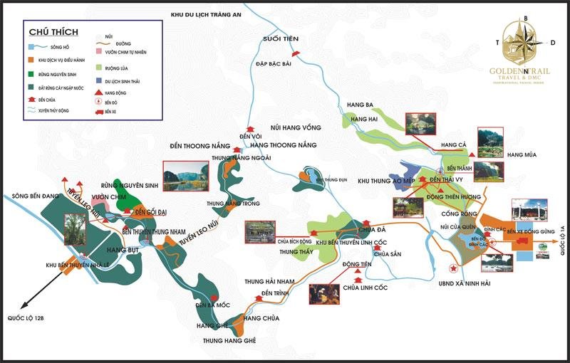
Overview of Ninh Binh’s Cycling Regions
Before diving into individual routes, you need to understand the main cycling regions featured on most Ninh Binh bicycle maps.
1. Tam Coc – The Heart of Cycling
This is where most travelers start their bike journey. Tam Coc is the gateway to:
Rice fields
Boat rides
Limestone valleys
Rural communities
Almost every cycling route begins or connects here.
2. Bich Dong Pagoda Area
Beautiful pagoda complexes built into mountains. It’s a popular short cycling route.
3. Trang An Landscape Complex
A UNESCO Heritage Site with water valleys, temples, and the most dramatic mountain scenery.
4. Mua Cave (Hang Mua)
Home to the iconic dragon statue viewpoint overlooking Tam Coc.
5. Hoa Lu Ancient Capital
The center of Vietnamese history during the 10th century.
6. Thung Nham Bird Park
A wildlife sanctuary ideal for nature lovers.
7. Van Long Nature Reserve
A quiet, untouched wetland area with calm waters and limestone cliffs.
Understanding these areas helps you interpret any Ninh Binh bicycle map more effectively.
The Most Essential Routes on the Ninh Binh Bicycle Map
This section breaks down every major cycling route you’ll find on the map. Each route includes distance, difficulty, highlights, and why it’s worth your time.
1. Tam Coc to Bich Dong Cycling Route
Overview
Distance: 3–4 km
Difficulty: Very Easy
Best for: Beginners, families, photographers
Route Description
The road cuts through rice fields and limestone peaks. The final stretch goes through a mountain corridor leading directly to Bich Dong Pagoda.
Highlights
Rice paddies
Lotus lakes
Local farmers
Peaceful temples
This route is ideal for sunrise or late afternoon.
2. Tam Coc to Mua Cave Cycling Route
Overview
Distance: 4–5 km
Difficulty: Easy
Best for: Active travelers
Route Description
Flat countryside roads lead you to Hang Mua, where you can climb 500 steps to reach one of Vietnam’s most famous viewpoints.
Highlights
Dragon Mountain viewpoint
Lotus pond
Scenic valley views
This route is on every Ninh Binh bicycle map for good reason.
3. Tam Coc to Trang An Cycling Route
Overview
Distance: 6–8 km
Difficulty: Easy to moderate
Best for: Nature lovers
Route Description
This route includes quiet roads and hidden valleys. Trang An has several boat tour routes that you can combine with your bike trip.
Highlights
Sacred temples
Water valleys
Mountain passes
4. Tam Coc to Hoa Lu Ancient Capital
Overview
Distance: 8–10 km
Difficulty: Moderate
Best for: Culture & history lovers
Route Description
This route follows scenic mountain roads and rural paths leading to temples from the 10th century.
Highlights
King Dinh Temple
King Le Temple
Ancient stone architecture
5. Tam Coc to Thung Nham Bird Park
Overview
Distance: 7–8 km
Difficulty: Moderate
Best for: Wildlife enthusiasts
Route Description
Quiet forest paths and water valleys take you to a large bird reserve ideal for sunset watching.
Highlights
Thousands of birds
Water caverns
Botanical gardens
6. Tam Coc to Van Long Nature Reserve
Overview
Distance: 15–20 km
Difficulty: Moderate to long
Best for: Long-distance cyclists
Route Description
This region is less touristy and offers calm wetlands, making it a relaxing alternative to the popular areas.
Highlights
Rare langurs
Birds
Still waters
Stunning cliffs
How to Read and Use a Ninh Binh Bicycle Map
Understanding map symbols is essential for safe and enjoyable cycling.
1. Path Types
Solid lines: paved roads
Dotted lines: small village paths
Dashed lines: off-road or gravel
2. Elevation Indicators
Although Ninh Binh is mostly flat, the map highlights:
Small slopes
Mountain passes
Viewpoints
3. Landmarks
Maps often highlight:
Temples
Boat stations
Pagodas
Bridges
Photo spots
4. Services on the Map
Icons may include:
Bike rental shops
Cafés
Rest stops
ATMs
Bathrooms
Understanding these symbols helps you navigate easily.
Recommended Full-Day Itineraries Based on the Bicycle Map
Below are itineraries that combine the best routes from the Ninh Binh bicycle map.
Full-Day Itinerary 1: Classic Highlights
Morning
Tam Coc → Bich Dong
Explore pagoda
Continue to Mua Cave
Climb for scenic views
Afternoon
Lunch in Tam Coc
Cycle to Trang An
Optional boat tour
Evening
Ride back through rice fields
Full-Day Itinerary 2: Culture and Nature
Morning
Tam Coc → Hoa Lu
Visit temples
Afternoon
Cycle into Trang An valleys
Take a boat tour
Late Afternoon
Return to Tam Coc
Full-Day Itinerary 3: Wildlife & Wetlands
Morning
Tam Coc → Thung Nham Bird Park
Afternoon
Explore bird reserve
Evening
Cycle back during golden hour
Cycling with Golden Trail Travel
For cyclists who want a professional, smooth, and insightful experience, Golden Trail Travel offers the best guided cycling tours in Ninh Binh.
Understanding the Ninh Binh bicycle map unlocks the true beauty of the region. With endless rice fields, limestone mountains, quiet villages, pagodas, and river valleys, Ninh Binh offers some of the most stunning cycling landscapes in Vietnam. Whether you explore alone or with a guide, cycling gives you the freedom to connect deeply with nature and local life.
For travelers who want a fully planned, safe, and meaningful cycling experience, Golden Trail Travel provides exceptional guided tours, quality bicycles, and deep local knowledge.
Golden Trail Travel Co., Ltd and Golden Cycling Tours would like to inform you of an important security notice.
Recently, we received warnings from Vietnamese authorities regarding an increase in online fraud targeting customers of travel companies and international businesses. Fraudsters are impersonating legitimate companies by using fake email addresses, forged payment instructions, and fraudulent bank account details to deceive customers into transferring funds.
These fraudulent emails are typically sent from unofficial email addresses and include fake banking information intended to redirect payments. This type of cybercrime, commonly known as phishing, is currently being reported and monitored by many organizations and government agencies.
To ensure the security of all transactions, Golden Trail Travel and Golden Cycling Tours use ONLY ONE official tax code and ONE official bank account as follows:
We will never request payment to any bank account other than the official account listed above.
Any phone number, email address, or payment information not included in our official contact details should be considered suspicious and potentially fraudulent.
Before making any payment, please contact us directly via our official hotline , WhatsApp or email addresses if you have any doubts or concerns.
If you receive any suspicious email or any request to change payment details, please notify us immediately so that we can verify the information and assist you.


.jpg "The Epic Cycling Adventure: Rediscovering Your Soul on Two Wheels")
.jpg "The Ultimate Trekking Expedition: A Journey Beyond Boundaries")
.jpg "The Ultimate Guide to Trekking Cao Bang Vietnam: Journey Through the Realm of Mountains and Waterfalls")
.webp "Cuc Phuong National Park Day Trip")
.jpg "Pu Luong Nature Reserve: An Ethereal Journey into Vietnam’s Hidden Eden")