Ha Giang Loop Map: The Complete Guide to Navigating Vietnam’s Most Legendary Road Trip
Ha Giang Loop Map: The Complete Guide to Navigating Vietnam’s Most Legendary Road Trip
BLOG
November 13, 2025
There are journeys that stay with you long after you’ve returned home — journeys that feel like they stretch beyond distance and time.
The Ha Giang Loop is one of those rare experiences.
Located in Vietnam’s far northern Highlands, bordering China’s Yunnan province, the Loop winds through razor-sharp limestone peaks, emerald valleys, rugged canyons, and ancient ethnic villages. It is a world of breathtaking contrasts — raw, wild, poetic, and unforgettable.
Ha Giang Loop Map: The Complete Guide to Navigating Vietnam’s Most Legendary Road Trip
But before every Ha Giang adventure comes the same essential question:
“What does the Ha Giang Loop map look like — and how do I navigate it safely?”
Understanding the Ha Giang Loop map is the key to unlocking a smooth, meaningful journey.
This guide will reveal everything:
The full Loop layout
Each region and town on the route
Distances
Travel times
Difficulty levels
Scenic highlights
Hidden gems not shown on basic tourist maps
Whether you plan to ride a motorbike, travel by car, or book an Easy Rider tour, this map-based guide will help you explore the Loop with confidence.
And for travelers seeking safe, expertly crafted routes, Golden Trail Travel & DMC provides professionally guided Ha Giang tours with detailed maps, local expertise, and curated stops:
👉 https://goldentrailtravel.com/
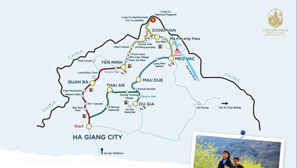
What Is the Ha Giang Loop? (Map Overview)
The Ha Giang Loop is a circular 300–350 km route starting and ending in Ha Giang City.
Most Ha Giang Loop maps divide the route into four major segments:
1️⃣ Ha Giang → Quan Ba
2️⃣ Quan Ba → Yen Minh → Dong Van
3️⃣ Dong Van → Ma Pi Leng Pass → Meo Vac
4️⃣ Meo Vac → Mau Due → Du Gia → Ha Giang
This forms a complete loop through the heart of the Dong Van Karst Plateau UNESCO Global Geopark, one of Asia’s most extraordinary landscapes.
Primary Length: 300–350 km
Ideal Duration: 3–4 days
Difficulty: Moderate to challenging
Navigation: 90% paved roads, 10% rough or steep segments
Different map variations include additional detours, such as:
Lung Cu Flag Tower
Nho Que River viewpoint
Hmong King’s Palace
Duong Thuong peaks
Ma Le village
Dong Van Ancient Quarter
Tham Ma Slope
Sky Path
Golden Trail Travel provides upgraded Ha Giang Loop maps that include these hidden locations, ensuring a richer and safer travel experience.
Ha Giang Loop Map: Key Regions Explained
To truly understand the Loop, you must understand each region.
Here is the full breakdown of what every part of the Ha Giang Loop map shows.
1. Ha Giang City (Starting Point on All Maps)
Every Loop map begins in Ha Giang City.
Located along the Lo River, this is where travelers pick up motorbikes, check gear, arrange permits, and receive safety briefings.
Ha Giang Loop Map
On most maps, Ha Giang City is labeled as:
📍 KM 0 — The Gateway to the North
Why Ha Giang City matters on the map:
All routes branch outward from here
It’s the safest base for returning the bike
It offers fuel, mechanics, and supplies
It’s where Golden Trail Travel provides your Loop orientation session
Must-see points near Ha Giang City:
Thon Tha Village
Ha Thanh Waterfall
Bamboo forests surrounding the city
These rarely appear on standard maps but are included in Golden Trail Travel’s premium map booklet.
2. Quan Ba: The Gateway to Heaven
On the map, Quan Ba lies just north of Ha Giang City.
Marked by dramatic elevation lines, curving mountain symbols, and the words “Heaven Gate”, this segment is famous for its panoramic landscapes.
Signature Landmarks on the Map:
Quan Ba Heaven Gate viewpoint
Twin Mountains (Fairy Bosom Hills)
Pine forests
Small Hmong hamlets scattered across cliffs
Quan Ba is often the first breathtaking moment on the Loop, showing travelers what awaits deeper in the mountains.
3. Yen Minh: The Green Valley Corridor
Maps usually represent Yen Minh with a long valley symbol or green shading.
This region is easier to ride and offers relief after the intense climb from Quan Ba.
Map Highlights:
Pine valley road
Low-rise farms
Tay and Hmong villages
Smooth, curving paths ideal for scenic stops
Yen Minh prepares travelers for the dramatic landscapes that come next.
4. Dong Van: The Cultural & Geographical Center of the Loop
Dong Van appears at the top of most Ha Giang maps — a major waypoint and cultural hub.
Cartographers often mark Dong Van with:
⭐ A town icon
⭐ Crossing roads
⭐ UNESCO geopark symbol
Dong Van is famous for:
Dong Van Ancient Quarter
Hmong King’s Palace
Tham Ma Pass
Lung Cu Flag Tower (detour shown on many maps)
The Lung Cu detour is indicated by a branching line leading north to Vietnam’s northernmost point, often labeled “Flag Tower — KM 0.”
Golden Trail Travel includes additional annotated map details:
Secret viewpoints
Morning photography spots
Non-touristy villages
These are not shown on basic Google Maps overlays.
5. Ma Pi Leng Pass: The Crown Jewel of the Ha Giang Loop Map
On any Ha Giang Loop map, Ma Pi Leng Pass is marked with bold lines, sharp curves, or highlighted elevation.
This is the most dramatic section of the Loop — a cliffside road carved above a deep canyon.
Map Features Include:
Nho Que River viewpoint
Sky Path (walking trail above the pass)
Danger points & narrow curves
High-wind zones
Panoramic stops
Most maps label this section as:
🔥 “Vietnam’s Most Beautiful Road”
Golden Trail Travel maps include safety markers and drone photo viewpoints along Ma Pi Leng for maximum enjoyment and safety.
6. Meo Vac: The Mountain Basin Town
South of Ma Pi Leng, the map shows Meo Vac — a circular valley town surrounded by steep peaks.
Map Highlights:
Meo Vac Sunday ethnic market
Boat access to certain river areas
Pathways leading to remote Hmong villages
This region is where the Loop transitions from dramatic karst cliffs to softer countryside.
7. Du Gia: The Peaceful Green Valley at the End of the Loop
Located southeast on the Loop map, Du Gia is represented by river symbols, terraces, and a waterfall icon.
Du Gia is known for:
Tay ethnic homestays
Du Gia Waterfall
Lush valleys
This region appears calm on the map — and it truly feels like a peaceful ending before returning to Ha Giang City.
Understanding Direction: Clockwise or Counterclockwise?
Most Ha Giang Loop maps show two options:
🔁 Clockwise Route
Ha Giang → Quan Ba → Yen Minh → Dong Van → Ma Pi Leng → Meo Vac → Du Gia → Ha Giang
✔ Best for beginners
✔ Better road conditions
✔ Standard with Golden Trail Travel
✔ Stable weather exposure
🔁 Counterclockwise Route
Ha Giang → Du Gia → Meo Vac → Ma Pi Leng → Dong Van → Yen Minh → Quan Ba → Ha Giang
✔ More challenging
✔ Steeper climbs early
✔ Preferred by experienced riders
Golden Trail Travel gives you both map versions during the safety briefing.
How to Read the Ha Giang Loop Map (Beginner-Friendly)
Most maps include symbols like:
🛣 Road quality
⛰ Elevation
📍 Viewpoints
🏘 Ethnic villages
⚠ Steep curves
🛑 Unsafe zones
⛽ Fuel stations
🏨 Homestays
🌿 Landscape zones
💧 Waterfalls
📸 Photo spots
Golden Trail Travel provides color-coded maps for:
Paved vs dirt roads
Beginner-friendly vs advanced segments
Weather-risk areas
Phone signal coverage
Emergency meeting points
Itineraries, Hidden Routes & Navigation Mastery
The Most Accurate Ha Giang Loop Map Itineraries (3D2N, 4D3N, 5D4N)
Different travelers use the Ha Giang Loop map in different ways. Some want the shortest route, others want the most scenic, and some want deep cultural immersion. Below are the three most reliable map-based itineraries used by experienced local guides and professional operators like Golden Trail Travel.
1. The Classic 3D2N Ha Giang Loop (Most Popular on Maps)
This itinerary is designed for travelers who want the full Loop experience in a shorter time.
🗺 Map Route:
Day 1: Ha Giang → Bac Sum Pass → Quan Ba → Yen Minh → Dong Van Day 2: Dong Van → Flag Tower → Dragon Spine → Ma Pi Leng Pass → Meo Vac Day 3: Meo Vac → Mau Due → Du Gia → Ha Giang
Distance: ~320 km
Who it’s for:
Travelers with limited time
Beginners or first-time visitors
Easy rider passengers
Map Highlights:
Quan Ba Heaven Gate
Yen Minh Pine Forest
Dong Van Ancient Town
Lung Cu Flag Tower (marked as a northern detour)
Ma Pi Leng Pass (UNESCO canyon zone)
Du Gia green valley
On the map, the 3D2N version is a perfect circle, connecting all four major districts.
Golden Trail Travel adds secret map markers for:
✔ Hidden cave viewpoint near Yen Minh
✔ Cliff-top café above Tham Ma Pass
✔ Non-touristy Hmong villages around Dong Van
2. Complete 4D3N Ha Giang Loop (Best for Photography & Deep Culture)
A slower, richer, more immersive version.
Recommended by pro riders and photographers.
🗺 Map Route:
Day 1: Ha Giang → Quan Ba → Nam Dam → Yen Minh Day 2: Yen Minh → Lung Cu → Dong Van → Ma Pi Leng Sky Path Day 3: Meo Vac → Khau Vai → Pa Vi → Du Gia Day 4: Du Gia → Lung Tam → Ha Giang
Distance: ~350 km
Who it’s for:
Photographers
Riders wanting less rush
Cultural travelers
Map Highlights:
Nam Dam eco-cultural village route
Sky Path above Ma Pi Leng Pass (shown as a dotted line on some maps)
Khau Vai Love Market region
Pa Vi Hmong cultural village
Lung Tam Hemp Weaving Village
The 4D3N route includes multiple narrow scenic detours not shown on Google Maps — Golden Trail Travel uses offline GPS maps for these.
3. Premium 5D4N Expanded Ha Giang Loop Map Version
For travelers who want everything — hidden valleys, remote villages, untouched nature.
🗺 Map Route:
Day 1: Ha Giang → Thon Tha → Quan Ba → Lung Khuy Caves → Nam Dam Day 2: Nam Dam → Yen Minh → Duong Thuong → Dong Van Day 3: Dong Van → Ma Le → Lung Cu → Ma Pi Leng → Meo Vac Day 4: Meo Vac → Xin Cai → H’Mong Ancient Road → Du Gia Day 5: Du Gia → Bamboo Forest Road → Ha Giang
Distance: ~380 km
Who it’s for:
Explorers
Drone videographers
Culture-focused travelers
Map Highlights:
Thon Tha Village (traditional Tay stilt houses)
Lung Khuy Cave systems
Duong Thuong’s hidden canyons
Ancient Hmong trading road (marked with dotted historic trail symbol)
Remote Xin Cai peak lines
Golden Trail Travel provides a premium laminated Loop map specifically for this expanded version.
Ha Giang Loop Map: Hidden Routes Most Tourists Miss
Standard tourist maps only show the main loop — but the real magic is often found on the side routes.
Here are the top hidden map routes the locals use:
1. The “Sky Path” Above Ma Pi Leng Pass
A narrow walking trail (sometimes drawn as a dotted red or yellow line) perched hundreds of meters above the pass.
Map codes often show:
✦ Cliff trail
✦ Photo icon
✦ Restricted for motorbikes
The Sky Path gives unmatched views of the Nho Que River canyon.
Golden Trail Travel’s detailed map shows 4 safe entry/exit points.
2. Tham Ma Pass Hidden Switchback Viewpoint
Marked only on local maps with a camera icon, this is the famous zigzag slope where Hmong people historically tested horses for strength.
Perfect for drone shots.
3. Lo Lo Chai Cultural Route (Near Lung Cu)
Near the Flag Tower, most tourists stop only at the tower itself.
But the map also shows a small loop road (tiny grey line) heading toward:
Traditional Lo Lo houses
Bronze drum heritage sites
Stone walls over 200 years old
Golden Trail Travel marks this with a “cultural detour” tag.
4. Remote villages around Pa Vi & Xin Cai
On the map, these appear as:
Thin brown roads
Small house icons
No fuel station icons
This signals untouched areas rarely visited by tourists.
5. Secret Waterfall Route in Du Gia
Local maps show an unmarked trail (dotted green line) leading to lesser-known waterfall pools.
Golden Trail Travel includes GPS pins to avoid getting lost.
Best Photography Points on the Ha Giang Loop Map
These viewpoints are clearly marked in Golden Trail Travel’s guided map.
⭐ Ma Pi Leng Panorama (main bend)
Bold yellow star on premium maps
Best for sunrise & sunset
⭐ Nho Que River (Tu San Canyon)
Marked with deep canyon lines and blue river symbols
⭐ Lung Cu Flag Tower (Vietnam’s northernmost point)
Marked with a red flag icon
⭐ Fairy Bosom Hills (Quan Ba)
Twin-mountain symbol
⭐ Tham Ma Slope
Zigzag symbol
⭐ Sky Path viewpoints
Diamond viewpoint symbol
Photographers say these locations are some of the most dramatic in Southeast Asia.
Navigation Tips for Reading the Ha Giang Loop Map
✔ Use offline maps
Signal disappears on 40% of the route.
Maps recommended:
Maps.me
OSMand
Golden Trail downloadable offline map
✔ Always check elevation lines
Steep areas are marked with tightly packed contour lines.
✔ Fuel station icons matter
On some segments (Dong Van → Meo Vac), fuel stations are very limited.
✔ Watch “⚠” symbols
These mark areas with:
landslides
steep drops
gravel sections
✔ Choose clockwise route if unsure
It is smoother and safer.
Weather & Map-Based Safety Planning
Match weather icons to map segments:
🌧 Rainy season (Jun–Aug)
Slippery roads
Landslide zones marked on maps
🍂 Dry cool season (Sept–Nov)
Best visibility
Most stable roads
❄ Winter (Dec–Feb)
Fog markers on high passes
Hidden curves
🌸 Spring (Mar–Apr)
Flower icons on maps (buckwheat + mustard flowers)
Golden Trail Travel provides season-specific maps for safety.
FAQs, Reviews, Conclusion & SEO Essentials
Real Traveler Reviews: What People Say After Using the Ha Giang Loop Map
⭐ “The map made everything so much easier.”
“I booked my Ha Giang Loop tour with Golden Trail Travel and their map was the most detailed I’d seen. It showed hidden spots, safe areas, and incredible viewpoints I’d never find alone.”
— Samuel B., UK
⭐ “Best navigation support in Ha Giang.”
“Google Maps helped, but Golden Trail’s local map had cultural routes and scenic stops. The Sky Path viewpoint wasn’t even marked online — only on their map.”
— Andrea M., Italy
⭐ “I felt safe the entire journey.”
“The map highlighted steep curves and areas without signal. It made planning easy and the ride much safer. Wouldn’t do the loop without it.”
— Chen Wei, Singapore
⭐ “The map turned a good trip into an unforgettable one.”
“Because of the detailed map, we found places like hidden waterfalls in Du Gia and quiet villages around Pa Vi. It felt like discovering a secret side of Vietnam.”
— Marta F., Spain
Frequently Asked Questions (FAQ)
1. Do I need a map for the Ha Giang Loop or can I just follow signs?
A map is essential because road signs in rural areas are limited, and many scenic detours are unmarked.
Golden Trail Travel provides the most reliable maps.
2. Can I use Google Maps for the Loop?
Yes, but Google Maps is not fully accurate in mountain regions.
Combine it with an offline map like Maps.me, plus a printed or digital Golden Trail Travel map for safety.
3. Does the Ha Giang Loop map show fuel stations?
Yes — detailed maps show fuel icons.
This is important because fuel can be limited between Dong Van → Meo Vac.
4. What is the safest direction to follow on the Loop map?
Clockwise is safer for beginners.
Counterclockwise includes steeper early climbs.
5. Will I lose phone signal on the route?
Yes. Around 40% of the Loop has weak or no signal.
This is why offline maps and paper maps are essential.
6. Are all hidden routes shown on the map?
Golden Trail Travel includes:
Secret viewpoints
Non-touristy villages
Local walking trails
Drone-friendly spots
These are rarely shown on standard tourist maps.
7. Can I get a Ha Giang Loop map if I book a tour?
Yes, most detailed maps show the northernmost detour and the cultural village route around Lo Lo Chai.
Conclusion: The Ha Giang Loop Map Is Your Gateway to Vietnam’s Wild Northern Frontier
The Ha Giang Loop is more than a road — it is a living masterpiece carved by nature and culture.
But to fully experience its magic, you need more than bravery and curiosity.
You need the right map.
A proper Ha Giang Loop map helps you:
avoid dangerous roads
find breathtaking viewpoints
discover hidden ethnic villages
explore cultural detours
choose the right direction
navigate safely without signal
enjoy the journey at your own rhythm
From the zigzag slopes of Tham Ma to the kingly cliffs of Ma Pi Leng, from peaceful Du Gia to vibrant Dong Van, the map transforms your adventure into a meaningful, unforgettable exploration.
And with Golden Trail Travel & DMC, you receive not just a map — but a complete support system:
✔ Local guides
✔ Expert drivers
✔ Cultural knowledge
✔ Offline map support
✔ Exclusive viewpoint pins
✔ Custom itineraries
If you want to explore Vietnam’s greatest road trip with confidence, beauty, and heart, there is no better starting point.
Recently, Golden Trail Travel Co., Ltd has identified several
fraudulent attempts in which scammers have used our company name,
logo, images, and brand identity to send fake payment requests to
customers.
These fraudulent emails are typically sent from unofficial email
addresses and may contain fake bank account details with the
intention of deceiving customers and misappropriating funds. This
type of phishing scam has been widely reported and warned against by
organizations and authorities worldwide.
To protect our customers and ensure secure transactions, Golden
Trail Travel and Golden Cycling Tours use ONLY ONE official tax code
and ONE official bank account as detailed below.
We never request customers to transfer payments to any bank
account other than the official account listed above.
Any phone number, email address, or payment information not listed
in this notice may be fraudulent.
If you receive any payment request that appears suspicious, please
contact us immediately through our official hotline or email
addresses to verify the information before making any payment.


.jpg "The Ultimate Guide to Trekking Cao Bang Vietnam: Journey Through the Realm of Mountains and Waterfalls")
.webp "Cuc Phuong National Park Day Trip")
.jpg "Pu Luong Nature Reserve: An Ethereal Journey into Vietnam’s Hidden Eden")
.webp "The Soul of the Sidewalk: An Emotional Journey Through Hanoi’s Street Food")
.webp "Co Loa Citadel Classic Tour: Stepping Into the Cradle of Vietnamese History")